Wednesday, March 31, 2010

Ranchers and Wolves!

Two local volunteers set up two local showings of the fantastic film “Lords of Nature” last week – one showing in Baker City and the other in Enterprise. There was great turnout at both showings, and the audience included many local ranchers. Then, the night after the Enterprise showing, Oregon’s only confirmed breeding wolf pack paid a visit to a ranch near Enterprise, digging up a buried cow carcass and coming closer to a ranch house than at any other time.

The Wallowa County Chieftain’s sensationalist headline screamed “Wolves at the Door: Wallowa County Ranchers Face Their Worst Fears.” This wolf activity and the preceding comments by some of the ranchers at the events gave me plenty to think about this week.

There were clearly a few over-the-top statements by some ranchers at the films. One claimed to be able to control all the threats to his livestock except for wolves. Yet he never did explain how he controlled the weather. This same rancher artificially inflated the number of livestock he had lost to wolves in order to make the threat sound much worse than it was, but in doing so he made a huge error: he admitted that he didn’t ear-tag all his calves and didn’t know for sure how many he sent out to pasture. His single-minded message was that he “needs the tools to control wolves,” which, in case it isn’t obvious, is just a euphemism for wanting to shoot wolves.

Another rancher said that he had no room to work with anyone on this issue, and that the only solution for him is that there are no wolves, period. His livestock allotment is on federal public land, in the heart of the Imnaha pack’s territory.

My initial thought after hearing the ranchers speak at the Lords of Nature showings was that I’ve never heard such a bunch of whiners. I thought ranchers prided themselves on their stoic, steady ability to deal with everything that gets thrown their way. I also thought they believed in fully functioning landscapes. The comments I heard came across more like a bunch of kids throwing a tantrum. I thought they sounded like the classic “bury the head in the sand” approach, refusing to admit change is happening even when it clearly is. I know these few vocal ranchers don’t necessarily speak for other ranchers who are indifferent about wolves or may even like wolves as long as wolves don’t kill livestock. But that reaction of mine to their comments isn’t very helpful either, and so I made myself move on to more constructive thoughts, namely, where do we go from here?

Step one, I think, is to admit as a community that change is happening. Wolves are here and they’re not going away. This is, after all, historic wolf country, and I’ve heard lots of people point out that the ranchers are the interlopers, not the wolves. There is also the growing recognition that our wildlands are not fully functioning without top predators like wolves.

But the fact remains that ranchers are operating in wolf country, so what do we do about that? Well, we have learned that the visit to the ranch by the Imnaha pack was not entirely random or unexpected. They were known to be in the area for at least a few days prior to the visit, and they dug up a recently buried cow carcass near the ranch.

We have better tools to deal with situations like this than we are currently applying. If wolves are in the area, we can set up fladry and other means of scaring wolves off … in advance of any wolf activity. We can practice better carcass disposal, or work together to devise a better system of dealing with carcasses. Ranchers operating in wolf country will have to avoid sloppy practices, and must know how many of their livestock are where. And not only ranchers, but wolf advocates can step up to deal with these situations (as some already do).

In my mind there is also a huge distinction between ranching operations on private land and those on public land. The Oregon Wolf Plan recognizes those distinctions, and ranchers must come to terms with that. After all, on national forests there is a legal mandate for maintaining viable wildlife populations. There is no legal mandate to allow ranching.

The primary point is that we need to be able to have conversations about these issues, away from the over-the-top rhetoric. I’m not confident, however, that we’ll get there. Anti-wolf rhetoric seems to be on the upswing. I suspect we’ll battle this out in the Oregon legislature, as we have for the last several sessions. The outspoken wolf opponents – and some of our politicians – want to make this into rural/urban issue, but it isn’t. There are wolf advocates throughout this state.

HCPC is a rural-based group, and we advocate for the return of wolves—and will continue to do so. Yet we also believe that there are solutions that can only come about with a joint commitment to solving these wolf-related issues. We challenge the ranching community to make the same commitment.
Greg Dyson
Executive Director

Thursday, March 18, 2010

HCPC Volunteers Help Restore Ladd Marsh


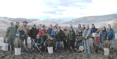
Story & photo by Brian Kelly, Restoration Coordinator


On a recent Saturday morning, HCPC volunteers worked on-the-ground to make the world a better place for native fish and wildlife. Well, to be more precise about it, they worked in the mud to make things better. Twenty-four volunteers planted four thousand native willow cuttings along the banks of Ladd Creek. The creek was recently re-constructed from a straightened ditch into a meandering stream channel. This configuration will provide improved habitat for fish and wildlife. Coyote willows and Booth willows were planted along the new stream bank. The willows will help stabilize the bank, shade the water, and will provide important habitat for birds and other animals.

Ladd Creek is located in the Ladd Marsh Wildlife Area at the southwest end of the Grande Ronde Valley. At just over six thousand acres, Ladd Marsh is the largest remaining wetland in northeast Oregon. Unique and diverse plants grow in the area and it is a haven for wildlife. Ladd Marsh Wildlife Area is home for fish, frogs, salamanders, deer, elk and pronghorn antelope, and many different kinds of birds, insects and other animals.

A dusting of new snow and a plethora of mud greeted us as we arrived at the creek to begin planting. Winston Morton of Oregon Department of Fish & Wildlife provided instructions and our valiant volunteers slogged through the mud with impressive enthusiasm. Shovels opened holes for the willow cuttings and the planters placed the willows in their new homes by the creek. Sandhill cranes serenaded us as we went about our planting. By noon, four thousand new willows had been planted along the creek.

I know that when I drive by Ladd Marsh in the future I will looking to see the young willows grow up into a new ecosystem.

Thanks to Oregon Department of Fish & Wildlife and Friends of Ladd Marsh.

Wednesday, March 10, 2010

Lawsuit Spurs Major First Step Towards Protecting the Wild Rapid River Watershed From Motorized Use


Hells Canyon Preservation Council joined its conservation allies, The Wilderness Society and Idaho Conservation League, in challenging a decision from the Payette National Forest that would unlawfully designate and allow trails for motorized recreation use within the Wild Rapid River Corridor, included in the Hells Canyon National Recreation Area, and the surrounding watershed.


The Rapid River Management Area is an ecological stronghold encompassing the Wild Rapid River and the Rapid River and Patrick Butte Roadless Areas. This watershed is the largest and best remaining fish habitat within the Little Salmon River system, providing crucial habitat for spring and summer Chinook salmon, Snake River Basin steelhead, and Columbia River bull trout, all of which are listed as “threatened” species pursuant to the Endangered Species Act.


This remaining aquatic stronghold is in large part due to the fact that there have been minimal land-disturbing activities in the Wild Rapid River--allowing near-natural habitat conditions to persist. The Wild Rapid River’s fisheries and water quality values also help support the Rapid River Fish Hatchery, which was built to mitigate lost runs of Chinook salmon caused by the construction and operation of the Hells Canyon Dam. Hells Canyon Dam – actually a “Complex” consisting of three dams – blocks salmon and steelhead from native spawning areas.


Both Congress and the Forest Service have acknowledged the Area’s ecological values and provided these values with strong legal safeguards. The Hells Canyon National Recreation Area Act (“HCNRA Act”) designated the Rapid River as a “wild river” and part of the National Wild & Scenic Rivers System created by the Wild and Scenic Rivers Act. The designation of the Rapid River as a “Wild” river affords legally-enforceable conservation protections to not only the waters of Wild Rapid River itself, but also to a corridor of lands surrounding these waters.


Despite these remarkable conservation and fisheries values, the Forest Service designated several motorized recreation routes incompatible with the Area’s legal safeguards. The construction and use of motorized trails are known to negatively affect water quality by accelerating erosion and delivering sediment to rivers and streams. Consequently, our conservation coalition, represented by the Western Environmental Law Center, filed suit in federal court to uphold the values envisioned by the Hells Canyon National Recreation Area Act—safeguards critical for protecting water quality and aquatic habitat, and which indirectly protect secure big game habitat and opportunities for solitude and quiet use recreation.


The good news is that on March 9, 2010 the Forest Service decided to officially issue a closure order prohibiting motorized use within the river corridor and on all trails that lead directly to the corridor area (see attached closure order & map). This is an incredibly important step forward. However, the Forest Service still has not closed several other routes that will adversely affect the health of the Rapid River watershed. These routes, notably, fall within a Roadless Area, one of our most protective conservation areas.


So while celebration is certainly in order, we will continue our efforts to resolve these remaining threats. There are many places on the Payette National Forest to ride off-road vehicles, but the Wild Rapid River and its surrounding watershed should be permanently protected for quiet recreation and crucial fish habitat!

Tuesday, March 9, 2010

Umatilla National Forest Proposes Giant Motorized Loop Trail for North and South Fork Walla Walla Rivers

by Janet Burcham
Janet Burcham of Walla Walla, Washington is the first guest contributor to HCPC's BLOG

Photo showing one of many motorized stream crossings on the North Fork Walla Walla River Trail. Motorized stream crossings are proven to be one of the worst offenders to water quality and fisheries on National Forests. photo credit: Janet Burcham


In the southeast corner of Washington and extending into the northeast corner of Oregon is a national forest that has been off the radar for oversight of responsible management of ATV/ORV use. This is the Umatilla National Forest (UNF), encompassing important headwaters of the Walla Walla River, long reaches of the Tucannon and Wenaha Rivers, Crooked Creek, Rock Creek and Butte Creek, and the Wenaha-Tucannon and North Fork Umatilla River Wilderness areas. Under the severely compromised application of NEPA to forest projects and practices during the Bush era, and due to the remoteness of this national forest from large, urban areas that tend to have a higher population of environmentally-sensitive recreationists, the ATVs, ORVs, dirt motorcycles, and 4-wheel drive trucks have run rampant with little or no monitoring and enforcement.

Throughout the summer of 2009, I hiked on the forest from trailheads into the Wenaha-Tucannon and North Fork Umatilla River Wilderness areas. I found extensive self-pioneered cross-country trails from ATVs/ORVs, vandalized “closed area” signs, and evidence of motorized incursions into designated Wilderness. I wrote several times identifying these areas and trailheads to the district rangers, the forest supervisor, and the Regional forester. I got no responses from the district rangers and placating answers from the other recipients.

Now the Forest Service is proposing to make a continuous motorized loop trail between the two forks of the Walla Walla River, linking the two trails at Deduct Pond. The Forest Service is categorically excluding the “Deduct Pond Trail Link” project from further NEPA analysis by artificially limiting the scope of the project area to the specific trail link area. Thus the Forest Service has segmented their analysis such that the impacts of the entire motorized loop system that will be newly established by this project can be overlooked. Currently, only motorcycles are permitted on the S. Fork trail, but “quads” or four-wheelers, are used on parts of the N. Fork trail. The current proposal will open up the north and south fork trail system to four-wheelers.

The comments submitted July 23, 2009, by the Hells Canyon Preservation Council accurately summarize the resource concerns. I also submitted comments with 7 pages of pictures showing the erosion and sediment delivery to the S. Fork Walla Walla River from the heavy motorcycle use. The pictures were taken from the popular Harris Park trailhead east of Milton-Freewater through Bureau of Land Management (BLM) lands to the US Forest Service (USFS) boundary. The BLM land is designated an area of critical environmental concern (ACEC). The South and North Forks of the Walla Walla River were proposed Jan. 13, 2010, as Critical Habitat for Bull Trout by the US Fish and Wildlife Service (USFWS) in a revision of the 2005 designation. The Walla Walla River (Hydrologic Unit No. 17070102) and adjacent riparian areas (see 50 CFR 424.12(b)) have been designated as Critical Habitat by the National Marine Fisheries Service (NMFS) for mid-Columbia River steelhead (Federal Register / Vol. 65, No. 32 / Wednesday, February 16, 2000 / Rules and Regulations).

My concerns are:

1) The S. Fork trail is immediately adjacent to the river and in many places there is no riparian vegetation. The soil is eroding due to motorized vehicles resulting in numerous areas where sediment laden water collects and drains directly into the river.

2) The North and South Fork Walla Walla River trails are open to hiking, horseback riding, mountain biking, backpacking, and are used to access hunting, fishing, camping areas, and designated old-growth timber areas and receive heavy horse traffic during hunting season. Connecting the trails to from a giant loop is very likely to encourage “races” and “time events” as on a BMX loop track. Faster speeds and heavier traffic will result in more trail damage and sediment delivery to the river, more damage to the riparian zone, and decreased public safety.

3) Monitoring and enforcement of off-road vehicles are inadequate to prevent and stop abuse that is occurring adjacent to even well-traveled forest service roads. So what can be expected from this new loop project that is more remote and therefore less likely to be monitored?

I am left wondering how federal agencies tasked with managing public resources responsibly and protecting endangered species can allow heavy motorized use in riparian areas and in a way that ensures erosion and delivery of sediments to waters identified as critical habitat for listed fish species. How is it that federal lands which are supposed to bear the burden of recovery efforts for listed species are treated in such a cavalier manner while commercial timber lands and farmers have been required to observe riparian protections, set-backs and specific placement, design and maintenance of roads, and numerous water quality protection measures? What is it about ORVs/ATVs/OHVs/motorcycles and their use as “recreation” that legitimizes their abuse of riparian zones and degradation of public lands and waters?

I also wonder why taxpayers would want to continue to support fish habitat recovery efforts and projects that have cost thousands if not tens of thousands of dollars in the Walla Walla River watershed to date only to have those efforts and dollars spent negated by ATVs/OHVs/ motorcycles driving along waterways and off-road on our public lands?

The cost of the required permit for driving ATVs/OHVs on the National Forest’s are trivial compared to the true costs of monitoring and enforcement and resource restoration that their abusive use necessitates. It costs $10 and is good for 2 years. This is not a fee collected by the federal agencies that goes towards the necessary costs of monitoring and enforcement. How much, if any, of the Oregon permit fees go to federal monitoring and enforcement efforts on national forest lands?

In summary, I contend that the designation of the proposed link between the S. Fork and N. Fork Walla Walla River trails as “Categorical Exclusion” is extremely inappropriate. I contend that there are definitely cumulative, and interrelated and interdependent effects and potential negative future impacts that must be evaluated by all the agencies responsible. I contend that continuing to piece-meal projects in isolation, such as this trail link, as separate and unrelated to the larger use and effects of this trail system is also extremely inappropriate. It is myopic to consider projects and their impacts only within the boundaries of one agency’s authority.