HCPC has been engaged in efforts to bring balance to a fuels reduction proposal on National Forest Lands near Cove, Oregon for two years. These remarkable public lands consist of towering multi-canopied old growth forests, extensive roadless forests that harbor salmon bearing streams, mountain hemlock stands rare to Eastern Oregon, and two Research Natural Areas where the natural processes of forest ecosystems are studied for the benefit of current and future generations (see photos below). However, other parts of the project area have been heavily logged and roaded- there was even a historic logging project up Indian Creek called "Nightmare!" That's why we think it is so important that the next management step we take in this area is positive for the forests, streams, wildlife, wildlands, and people that love these wonderful treasures.
When it comes to fuels reduction, HCPC supports work that protects communities and firefighters and also protects the areas outstanding natural values. To this end we are thrilled that HCPC reached an agreement with the Forest Service resulting in the following modifications to the proposal.
1. Eliminates 413 acres of commercial logging in old growth forests.
2. Drops or changes to non-commercial all commercial harvest (618 acres) from designated “Backcountry” areas.
3. Reduces temporary road building from 2 miles to less than .5 miles.
4. Buffers the Eagle Cap Wilderness from commercial logging and road building.
5. Protects the integrity of Castle Ridge Potential Wilderness Area.
6. With the exception of work needed for resource protection, drops the proposed road reconstruction on the 6220 road north of Moss Springs and the associated rock quarry expansion.
7. Drops proposed boundary change to the Point Prominence Research Natural Area.
8. A monitoring plan will be developed to better understand effects of the remaining treatments in old growth forests.
With these changes, the proposal now protects the incredible natural resources on National Forest lands near Cove, Oregon, while moving forward with important fuels reduction work that will improve community and firefighter safety. Here are a some pictures of this incredible area.  This view is from the Dunns Bluff Inventoried Roadless area looking into the heart of the Castle Ridge Inventoried Roadless Area. HCPC has asked that the special rock outcroppings known as monadnocks be considered for designation as a Geological Area in the Blue Mountains Forest Plan Revision Process. While much more subtle from the Grande Ronde Valley, these formations can be seen from several vantage points.
  This photo of Indian Creek within the Castle Ridge Roadless Area shows the features that allow this beautiful stream to support salmon; large downed wood, gravelly stream bottom, and shading from the riparian vegetation that cools water temperatures.
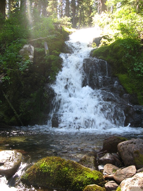 A mystical waterfall on Indian Creek within the Castle Ridge Roadless area and near the Indian Creek Research Natural Area. Finding treasures like this when your exploring the backcountry is absolutely priceless and helps us to connect to the beauty of world that we are part of.
It's not all a pretty picture in the Castle Ridge Roadless area though, as the Breshears OHV trail cuts through the heart of the roadless area (next photo), diminishing habitat security for wildlife, and degrading the aquatic integrity of the area (second photo below).

 The Indian Creek Research Natural Area includes climax lodgepole pine forests, unique rock outrcoppings, the headwaters of Indian Creek and much more. The role these Research Natural Areas play in wildlife connectivity needs to be better considered in future planning of this area. While political boundaries might distinguish the Research Natural Area from the directly adjacent Eagle Cap Wilderness, try telling that to a marten, lynx, or wolverine, that need all of this habitat, together, to survive.
 The Point Prominence Research Natural Area protects these high elevation mountain hemlock forests that only exist in eastern Oregon in scattered pockets. Some high elevation plant communties are predicted to be casualties of global warming because they cannot shift their range to higher elevations in order to adjust to the rising temperature. Will these Mountain Hemlock forests be lost from the Wallowas? These are the types of questions that should be studied in Research Natural Areas.
Thank you for everything you did to help us protect this part of our National Forest right here in our backyard!!
Post by David Mildrexler, Ecosystem Conservation Coordinator Hells Canyon Preservation Council

No comments:
Post a Comment